|
|
|||||||||||||||||
| Point ID: 693 | Downloads | Plots | Site Data | Code: 07CB002 |
|
|
|||||||||||||||||
| Download | |
|---|---|
| Site Descriptor Information | Site Time Series Data |
| Link to all available data | |
| View: | Time Series | All |
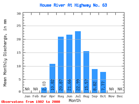
| Units: | m3/s |
| Statistic | Jan | Feb | Mar | Apr | May | Jun | Jul | Aug | Sep | Oct | Nov | Dec | Annual |
|---|---|---|---|---|---|---|---|---|---|---|---|---|---|
| Mean | 2.03 | 10.81 | 20.87 | 21.66 | 22.99 | 15.57 | 8.82 | 7.76 | |||||
| Standard Deviation | 0.58 | 5.32 | 17.87 | 16.60 | 18.66 | 16.21 | 8.60 | 8.11 | |||||
| Min | 0.97 | 4.04 | 4.49 | 4.00 | 2.37 | 0.70 | 1.09 | 2.21 | |||||
| Max | 3.17 | 25.31 | 56.08 | 53.94 | 85.18 | 65.55 | 35.62 | 31.69 | |||||
| Coefficient of Variation | 0.28 | 0.49 | 0.86 | 0.77 | 0.81 | 1.04 | 0.97 | 1.04 |
 Return to R-Arctic Net Home Page