|
|
|||||||||||||||||
| Point ID: 6922 | Downloads | Plots | Site Data | Code: 10586 |
|
|
|||||||||||||||||
| Download | |
|---|---|
| Site Descriptor Information | Site Time Series Data |
| Link to all available data | |
| View: | Time Series | All |
| Units: | m3/s |
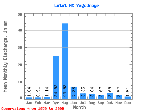
| Statistic | Jan | Feb | Mar | Apr | May | Jun | Jul | Aug | Sep | Oct | Nov | Dec | Annual |
|---|---|---|---|---|---|---|---|---|---|---|---|---|---|
| Mean | 1.04 | 0.92 | 1.14 | 24.93 | 43.91 | 7.28 | 3.34 | 3.04 | 2.67 | 3.69 | 2.52 | 1.51 | 95.58 |
| Standard Deviation | 0.52 | 0.47 | 0.57 | 18.23 | 25.55 | 3.32 | 1.35 | 1.63 | 1.51 | 2.39 | 1.09 | 0.68 | 34.26 |
| Min | 0.25 | 0.28 | 0.25 | 0.72 | 6.54 | 2.21 | 0.77 | 0.60 | 0.46 | 0.76 | 0.76 | 0.50 | 42.54 |
| Max | 2.52 | 1.94 | 2.36 | 66.02 | 117.36 | 15.32 | 5.75 | 6.77 | 6.02 | 10.63 | 5.34 | 2.84 | 161.51 |
| Coefficient of Variation | 0.50 | 0.51 | 0.50 | 0.73 | 0.58 | 0.46 | 0.40 | 0.54 | 0.57 | 0.65 | 0.43 | 0.45 | 0.36 |
 Return to R-Arctic Net Home Page