|
|
|||||||||||||||||
| Point ID: 6902 | Downloads | Plots | Site Data | Code: 10559 |
|
|
|||||||||||||||||
| Download | |
|---|---|
| Site Descriptor Information | Site Time Series Data |
| Link to all available data | |
| View: | Time Series | All |
| Units: | m3/s |
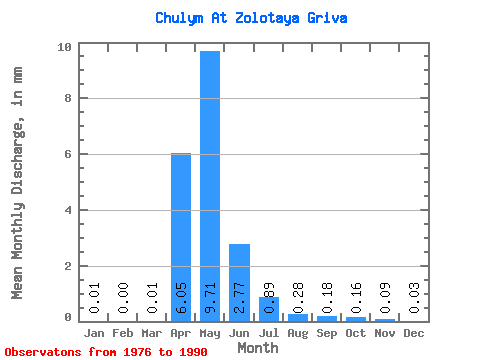
| Statistic | Jan | Feb | Mar | Apr | May | Jun | Jul | Aug | Sep | Oct | Nov | Dec | Annual |
|---|---|---|---|---|---|---|---|---|---|---|---|---|---|
| Mean | 0.01 | 0.00 | 0.01 | 6.05 | 9.70 | 2.77 | 0.89 | 0.28 | 0.17 | 0.16 | 0.10 | 0.03 | 29.57 |
| Standard Deviation | 0.01 | 0.01 | 0.02 | 5.16 | 15.68 | 5.19 | 1.72 | 0.45 | 0.28 | 0.27 | 0.18 | 0.05 | 39.88 |
| Min | 0.00 | 0.00 | 0.00 | 1.54 | 0.37 | 0.01 | 0.01 | 0.01 | 0.01 | 0.01 | 0.01 | 0.00 | 2.80 |
| Max | 0.04 | 0.02 | 0.04 | 16.17 | 56.55 | 18.42 | 5.97 | 1.58 | 0.88 | 0.94 | 0.65 | 0.18 | 99.17 |
| Coefficient of Variation | 1.63 | 1.77 | 1.76 | 0.85 | 1.61 | 1.87 | 1.92 | 1.61 | 1.61 | 1.67 | 1.92 | 1.58 | 1.35 |
 Return to R-Arctic Net Home Page