|
|
|||||||||||||||||
| Point ID: 6894 | Downloads | Plots | Site Data | Code: 10548 |
|
|
|||||||||||||||||
| Download | |
|---|---|
| Site Descriptor Information | Site Time Series Data |
| Link to all available data | |
| View: | Time Series | All |
| Units: | m3/s |
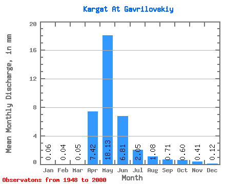
| Statistic | Jan | Feb | Mar | Apr | May | Jun | Jul | Aug | Sep | Oct | Nov | Dec | Annual |
|---|---|---|---|---|---|---|---|---|---|---|---|---|---|
| Mean | 0.06 | 0.04 | 0.05 | 7.42 | 18.13 | 6.81 | 2.05 | 1.08 | 0.71 | 0.60 | 0.41 | 0.12 | 41.24 |
| Standard Deviation | 0.10 | 0.07 | 0.06 | 6.39 | 19.72 | 10.16 | 4.12 | 2.50 | 1.73 | 1.29 | 0.85 | 0.20 | 40.87 |
| Min | 0.00 | 0.00 | 0.00 | 0.68 | 0.23 | 0.02 | 0.00 | 0.01 | 0.01 | 0.01 | 0.01 | 0.00 | 3.46 |
| Max | 0.64 | 0.42 | 0.29 | 30.03 | 86.30 | 46.07 | 19.79 | 13.56 | 10.28 | 6.64 | 4.20 | 1.31 | 192.41 |
| Coefficient of Variation | 1.64 | 1.58 | 1.24 | 0.86 | 1.09 | 1.49 | 2.01 | 2.31 | 2.43 | 2.17 | 2.05 | 1.65 | 0.99 |
 Return to R-Arctic Net Home Page