|
|
|||||||||||||||||
| Point ID: 689 | Downloads | Plots | Site Data | Code: 07CA011 |
|
|
|||||||||||||||||
| Download | |
|---|---|
| Site Descriptor Information | Site Time Series Data |
| Link to all available data | |
| View: | Time Series | All |
| Units: | m3/s |
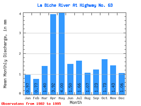
| Statistic | Jan | Feb | Mar | Apr | May | Jun | Jul | Aug | Sep | Oct | Nov | Dec | Annual |
|---|---|---|---|---|---|---|---|---|---|---|---|---|---|
| Mean | 0.94 | 0.76 | 1.36 | 3.83 | 3.90 | 1.46 | 1.62 | 1.05 | 1.20 | 1.68 | 1.39 | 1.03 | 21.22 |
| Standard Deviation | 0.75 | 0.66 | 1.21 | 2.28 | 2.21 | 0.81 | 2.42 | 0.71 | 0.94 | 1.50 | 1.33 | 0.80 | 12.41 |
| Min | 0.00 | 0.00 | 0.04 | 1.05 | 1.07 | 0.32 | 0.17 | 0.22 | 0.16 | 0.24 | 0.20 | 0.06 | 4.19 |
| Max | 2.12 | 1.98 | 3.85 | 8.53 | 8.93 | 3.35 | 9.42 | 2.72 | 3.35 | 4.80 | 4.91 | 2.56 | 38.85 |
| Coefficient of Variation | 0.80 | 0.87 | 0.89 | 0.60 | 0.57 | 0.55 | 1.49 | 0.68 | 0.78 | 0.89 | 0.95 | 0.77 | 0.58 |
 Return to R-Arctic Net Home Page