|
|
|||||||||||||||||
| Point ID: 6887 | Downloads | Plots | Site Data | Code: 10532 |
|
|
|||||||||||||||||
| Download | |
|---|---|
| Site Descriptor Information | Site Time Series Data |
| Link to all available data | |
| View: | Time Series | All |
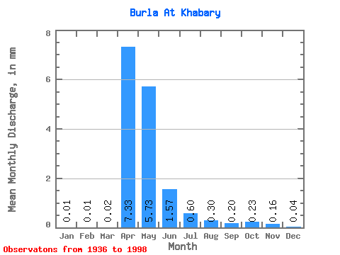
| Units: | m3/s |
| Statistic | Jan | Feb | Mar | Apr | May | Jun | Jul | Aug | Sep | Oct | Nov | Dec | Annual |
|---|---|---|---|---|---|---|---|---|---|---|---|---|---|
| Mean | 0.01 | 0.01 | 0.02 | 7.33 | 5.72 | 1.57 | 0.60 | 0.30 | 0.20 | 0.23 | 0.16 | 0.04 | 22.46 |
| Standard Deviation | 0.01 | 0.01 | 0.02 | 7.88 | 6.27 | 1.44 | 0.68 | 0.36 | 0.23 | 0.28 | 0.16 | 0.04 | 18.29 |
| Min | 0.00 | 0.00 | 0.00 | 0.15 | 0.10 | 0.04 | 0.02 | 0.00 | 0.00 | 0.00 | 0.00 | 0.00 | 1.88 |
| Max | 0.04 | 0.04 | 0.08 | 37.76 | 24.30 | 5.95 | 3.07 | 1.79 | 1.05 | 1.67 | 0.66 | 0.16 | 55.97 |
| Coefficient of Variation | 1.05 | 1.47 | 1.27 | 1.08 | 1.09 | 0.92 | 1.12 | 1.20 | 1.20 | 1.23 | 1.00 | 1.02 | 0.81 |
 Return to R-Arctic Net Home Page