|
|
|||||||||||||||||
| Point ID: 6883 | Downloads | Plots | Site Data | Code: 10511 |
|
|
|||||||||||||||||
| Download | |
|---|---|
| Site Descriptor Information | Site Time Series Data |
| Link to all available data | |
| View: | Time Series | All |
| Units: | m3/s |
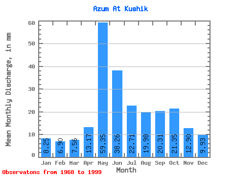
| Statistic | Jan | Feb | Mar | Apr | May | Jun | Jul | Aug | Sep | Oct | Nov | Dec | Annual |
|---|---|---|---|---|---|---|---|---|---|---|---|---|---|
| Mean | 8.25 | 6.96 | 7.55 | 13.18 | 59.34 | 38.26 | 22.71 | 19.98 | 20.31 | 21.35 | 12.90 | 9.93 | 238.51 |
| Standard Deviation | 1.45 | 1.03 | 1.09 | 10.02 | 21.15 | 12.34 | 9.05 | 13.58 | 9.24 | 11.82 | 4.43 | 2.54 | 51.71 |
| Min | 5.50 | 4.96 | 4.87 | 5.21 | 22.94 | 19.68 | 11.48 | 9.64 | 8.41 | 8.20 | 7.12 | 5.10 | 170.13 |
| Max | 11.34 | 9.29 | 9.71 | 47.78 | 104.09 | 65.81 | 44.24 | 78.48 | 48.23 | 59.38 | 24.34 | 16.63 | 388.12 |
| Coefficient of Variation | 0.18 | 0.15 | 0.14 | 0.76 | 0.36 | 0.32 | 0.40 | 0.68 | 0.46 | 0.55 | 0.34 | 0.26 | 0.22 |
 Return to R-Arctic Net Home Page