|
|
|||||||||||||||||
| Point ID: 6882 | Downloads | Plots | Site Data | Code: 10509 |
|
|
|||||||||||||||||
| Download | |
|---|---|
| Site Descriptor Information | Site Time Series Data |
| Link to all available data | |
| View: | Time Series | All |
| Units: | m3/s |
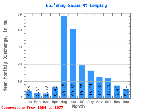
| Statistic | Jan | Feb | Mar | Apr | May | Jun | Jul | Aug | Sep | Oct | Nov | Dec | Annual |
|---|---|---|---|---|---|---|---|---|---|---|---|---|---|
| Mean | 4.05 | 2.97 | 2.79 | 6.42 | 48.14 | 40.50 | 19.24 | 16.24 | 12.32 | 11.75 | 7.47 | 5.24 | 175.36 |
| Standard Deviation | 1.36 | 0.81 | 0.65 | 3.95 | 19.07 | 19.53 | 11.87 | 9.37 | 7.08 | 7.25 | 3.49 | 1.90 | 51.83 |
| Min | 2.33 | 1.69 | 1.51 | 1.85 | 21.42 | 10.45 | 7.69 | 4.99 | 4.25 | 4.11 | 2.88 | 3.26 | 97.37 |
| Max | 6.43 | 4.16 | 3.62 | 14.52 | 78.20 | 78.59 | 49.70 | 34.71 | 25.71 | 30.85 | 15.10 | 10.03 | 249.81 |
| Coefficient of Variation | 0.34 | 0.27 | 0.23 | 0.62 | 0.40 | 0.48 | 0.62 | 0.58 | 0.57 | 0.62 | 0.47 | 0.36 | 0.30 |
 Return to R-Arctic Net Home Page