|
|
|||||||||||||||||
| Point ID: 6877 | Downloads | Plots | Site Data | Code: 10503 |
|
|
|||||||||||||||||
| Download | |
|---|---|
| Site Descriptor Information | Site Time Series Data |
| Link to all available data | |
| View: | Time Series | All |
| Units: | m3/s |
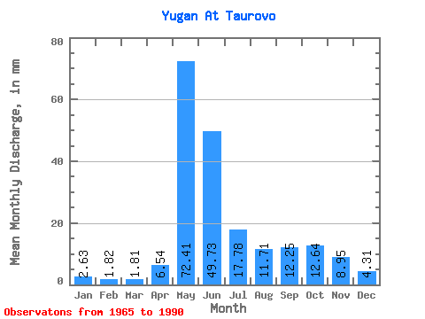
| Statistic | Jan | Feb | Mar | Apr | May | Jun | Jul | Aug | Sep | Oct | Nov | Dec | Annual |
|---|---|---|---|---|---|---|---|---|---|---|---|---|---|
| Mean | 2.63 | 1.84 | 1.81 | 6.54 | 72.40 | 49.73 | 17.77 | 11.71 | 12.26 | 12.64 | 8.95 | 4.31 | 198.34 |
| Standard Deviation | 0.92 | 0.51 | 0.37 | 5.89 | 16.82 | 25.04 | 15.30 | 9.98 | 9.90 | 8.94 | 5.57 | 2.06 | 57.71 |
| Min | 1.48 | 1.19 | 1.22 | 1.51 | 32.96 | 8.21 | 3.87 | 2.10 | 2.07 | 2.43 | 1.59 | 1.63 | 99.64 |
| Max | 4.96 | 3.02 | 2.55 | 23.13 | 99.70 | 94.71 | 63.65 | 42.23 | 32.10 | 33.17 | 19.74 | 8.22 | 319.60 |
| Coefficient of Variation | 0.35 | 0.28 | 0.20 | 0.90 | 0.23 | 0.50 | 0.86 | 0.85 | 0.81 | 0.71 | 0.62 | 0.48 | 0.29 |
 Return to R-Arctic Net Home Page