|
|
|||||||||||||||||
| Point ID: 6874 | Downloads | Plots | Site Data | Code: 10500 |
|
|
|||||||||||||||||
| Download | |
|---|---|
| Site Descriptor Information | Site Time Series Data |
| Link to all available data | |
| View: | Time Series | All |
| Units: | m3/s |
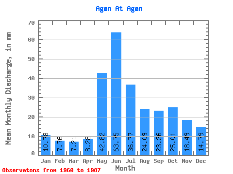
| Statistic | Jan | Feb | Mar | Apr | May | Jun | Jul | Aug | Sep | Oct | Nov | Dec | Annual |
|---|---|---|---|---|---|---|---|---|---|---|---|---|---|
| Mean | 10.78 | 7.83 | 7.21 | 8.29 | 42.82 | 63.75 | 36.76 | 24.08 | 23.26 | 25.00 | 18.49 | 14.79 | 291.86 |
| Standard Deviation | 4.16 | 2.33 | 1.42 | 2.29 | 16.35 | 19.00 | 15.40 | 10.37 | 10.75 | 12.14 | 8.55 | 7.04 | 65.19 |
| Min | 6.00 | 4.30 | 4.45 | 4.23 | 11.27 | 29.32 | 20.02 | 12.80 | 12.30 | 12.35 | 9.43 | 7.78 | 206.12 |
| Max | 24.53 | 13.39 | 10.01 | 14.49 | 74.12 | 92.51 | 70.78 | 46.62 | 51.32 | 53.92 | 45.91 | 39.04 | 414.31 |
| Coefficient of Variation | 0.39 | 0.30 | 0.20 | 0.28 | 0.38 | 0.30 | 0.42 | 0.43 | 0.46 | 0.49 | 0.46 | 0.48 | 0.22 |
 Return to R-Arctic Net Home Page