|
|
|||||||||||||||||
| Point ID: 6872 | Downloads | Plots | Site Data | Code: 10498 |
|
|
|||||||||||||||||
| Download | |
|---|---|
| Site Descriptor Information | Site Time Series Data |
| Link to all available data | |
| View: | Time Series | All |
| Units: | m3/s |
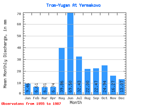
| Statistic | Jan | Feb | Mar | Apr | May | Jun | Jul | Aug | Sep | Oct | Nov | Dec | Annual |
|---|---|---|---|---|---|---|---|---|---|---|---|---|---|
| Mean | 9.46 | 6.67 | 6.31 | 6.74 | 39.85 | 69.50 | 32.42 | 22.00 | 22.47 | 24.94 | 16.27 | 13.07 | 263.39 |
| Standard Deviation | 2.97 | 1.85 | 1.48 | 2.06 | 20.48 | 23.32 | 10.64 | 6.98 | 8.49 | 11.70 | 6.28 | 5.63 | 52.17 |
| Min | 5.22 | 3.69 | 3.69 | 3.21 | 6.57 | 24.77 | 16.86 | 10.04 | 10.91 | 9.82 | 5.43 | 5.57 | 178.31 |
| Max | 17.40 | 11.31 | 9.36 | 11.77 | 81.93 | 110.02 | 55.34 | 39.08 | 38.59 | 49.00 | 29.76 | 28.17 | 330.07 |
| Coefficient of Variation | 0.31 | 0.28 | 0.23 | 0.30 | 0.51 | 0.34 | 0.33 | 0.32 | 0.38 | 0.47 | 0.39 | 0.43 | 0.20 |
 Return to R-Arctic Net Home Page