|
|
|||||||||||||||||
| Point ID: 6870 | Downloads | Plots | Site Data | Code: 10496 |
|
|
|||||||||||||||||
| Download | |
|---|---|
| Site Descriptor Information | Site Time Series Data |
| Link to all available data | |
| View: | Time Series | All |
| Units: | m3/s |
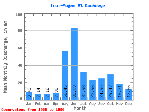
| Statistic | Jan | Feb | Mar | Apr | May | Jun | Jul | Aug | Sep | Oct | Nov | Dec | Annual |
|---|---|---|---|---|---|---|---|---|---|---|---|---|---|
| Mean | 9.43 | 7.21 | 7.12 | 7.96 | 56.45 | 83.09 | 31.98 | 22.95 | 24.91 | 29.46 | 18.31 | 12.86 | 313.75 |
| Standard Deviation | 2.64 | 2.09 | 2.12 | 3.11 | 31.94 | 37.31 | 11.30 | 9.15 | 10.23 | 14.62 | 7.65 | 4.47 | 72.56 |
| Min | 5.71 | 4.29 | 4.62 | 4.23 | 9.51 | 23.75 | 14.76 | 11.15 | 10.09 | 8.87 | 7.47 | 6.90 | 177.95 |
| Max | 14.30 | 12.03 | 12.80 | 15.66 | 121.10 | 148.18 | 58.04 | 45.15 | 43.52 | 66.27 | 38.70 | 23.54 | 449.30 |
| Coefficient of Variation | 0.28 | 0.29 | 0.30 | 0.39 | 0.57 | 0.45 | 0.35 | 0.40 | 0.41 | 0.50 | 0.42 | 0.35 | 0.23 |
 Return to R-Arctic Net Home Page