|
|
|||||||||||||||||
| Point ID: 6863 | Downloads | Plots | Site Data | Code: 10483 |
|
|
|||||||||||||||||
| Download | |
|---|---|
| Site Descriptor Information | Site Time Series Data |
| Link to all available data | |
| View: | Time Series | All |
| Units: | m3/s |
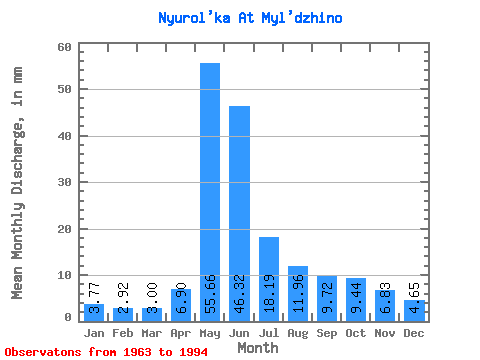
| Statistic | Jan | Feb | Mar | Apr | May | Jun | Jul | Aug | Sep | Oct | Nov | Dec | Annual |
|---|---|---|---|---|---|---|---|---|---|---|---|---|---|
| Mean | 3.77 | 2.94 | 3.00 | 6.90 | 55.65 | 46.32 | 18.18 | 11.96 | 9.72 | 9.44 | 6.83 | 4.64 | 178.66 |
| Standard Deviation | 0.97 | 0.59 | 0.49 | 3.71 | 14.72 | 21.20 | 13.82 | 8.33 | 6.10 | 4.09 | 2.83 | 1.65 | 50.26 |
| Min | 2.50 | 1.96 | 1.89 | 2.63 | 22.95 | 9.54 | 5.30 | 4.10 | 4.22 | 4.60 | 3.22 | 2.22 | 95.99 |
| Max | 6.83 | 4.58 | 4.00 | 16.60 | 80.27 | 81.24 | 62.95 | 37.97 | 28.24 | 16.62 | 13.86 | 8.49 | 298.50 |
| Coefficient of Variation | 0.26 | 0.20 | 0.16 | 0.54 | 0.27 | 0.46 | 0.76 | 0.70 | 0.63 | 0.43 | 0.41 | 0.36 | 0.28 |
 Return to R-Arctic Net Home Page