|
|
|||||||||||||||||
| Point ID: 6862 | Downloads | Plots | Site Data | Code: 10480 |
|
|
|||||||||||||||||
| Download | |
|---|---|
| Site Descriptor Information | Site Time Series Data |
| Link to all available data | |
| View: | Time Series | All |
| Units: | m3/s |
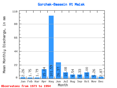
| Statistic | Jan | Feb | Mar | Apr | May | Jun | Jul | Aug | Sep | Oct | Nov | Dec | Annual |
|---|---|---|---|---|---|---|---|---|---|---|---|---|---|
| Mean | 2.26 | 1.77 | 1.80 | 15.05 | 101.57 | 26.36 | 10.06 | 6.54 | 6.32 | 10.01 | 5.25 | 2.86 | 186.44 |
| Standard Deviation | 0.89 | 0.49 | 0.45 | 11.13 | 79.76 | 18.58 | 12.48 | 8.49 | 5.50 | 10.26 | 5.90 | 1.52 | 110.87 |
| Min | 1.22 | 0.91 | 0.97 | 1.79 | 19.05 | 2.67 | 1.74 | 1.38 | 1.39 | 1.41 | 1.18 | 1.27 | 49.18 |
| Max | 4.69 | 2.77 | 2.73 | 46.23 | 287.13 | 58.25 | 47.49 | 39.20 | 21.11 | 36.72 | 28.06 | 7.18 | 401.79 |
| Coefficient of Variation | 0.40 | 0.28 | 0.25 | 0.74 | 0.79 | 0.70 | 1.24 | 1.30 | 0.87 | 1.02 | 1.12 | 0.53 | 0.59 |
 Return to R-Arctic Net Home Page