|
|
|||||||||||||||||
| Point ID: 6861 | Downloads | Plots | Site Data | Code: 10479 |
|
|
|||||||||||||||||
| Download | |
|---|---|
| Site Descriptor Information | Site Time Series Data |
| Link to all available data | |
| View: | Time Series | All |
| Units: | m3/s |
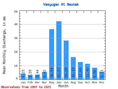
| Statistic | Jan | Feb | Mar | Apr | May | Jun | Jul | Aug | Sep | Oct | Nov | Dec | Annual |
|---|---|---|---|---|---|---|---|---|---|---|---|---|---|
| Mean | 4.23 | 3.42 | 3.44 | 5.42 | 36.54 | 42.27 | 28.28 | 16.13 | 12.60 | 11.39 | 8.56 | 5.71 | 177.36 |
| Standard Deviation | 1.17 | 0.76 | 0.82 | 2.66 | 8.33 | 12.30 | 15.37 | 10.46 | 7.87 | 7.25 | 4.59 | 2.25 | 55.19 |
| Min | 2.59 | 2.10 | 2.10 | 2.98 | 19.29 | 11.56 | 8.77 | 6.71 | 5.29 | 4.36 | 3.91 | 2.95 | 84.43 |
| Max | 6.20 | 4.60 | 4.49 | 13.83 | 48.69 | 59.58 | 60.63 | 42.12 | 29.25 | 28.25 | 19.25 | 9.65 | 274.76 |
| Coefficient of Variation | 0.28 | 0.22 | 0.24 | 0.49 | 0.23 | 0.29 | 0.54 | 0.65 | 0.62 | 0.64 | 0.54 | 0.39 | 0.31 |
 Return to R-Arctic Net Home Page