|
|
|||||||||||||||||
| Point ID: 6859 | Downloads | Plots | Site Data | Code: 10476 |
|
|
|||||||||||||||||
| Download | |
|---|---|
| Site Descriptor Information | Site Time Series Data |
| Link to all available data | |
| View: | Time Series | All |
| Units: | m3/s |
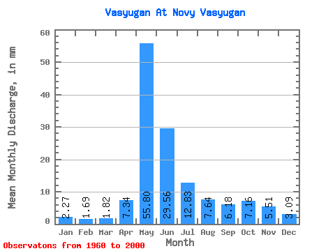
| Statistic | Jan | Feb | Mar | Apr | May | Jun | Jul | Aug | Sep | Oct | Nov | Dec | Annual |
|---|---|---|---|---|---|---|---|---|---|---|---|---|---|
| Mean | 2.27 | 1.70 | 1.81 | 7.34 | 55.79 | 29.55 | 12.83 | 7.63 | 6.18 | 7.16 | 5.50 | 3.09 | 140.10 |
| Standard Deviation | 0.85 | 0.53 | 0.50 | 5.63 | 22.86 | 21.38 | 13.55 | 7.19 | 4.65 | 5.00 | 4.13 | 1.66 | 58.54 |
| Min | 0.03 | 0.02 | 0.03 | 1.71 | 5.55 | 0.49 | 0.20 | 0.04 | 0.02 | 0.04 | 0.03 | 0.00 | 9.50 |
| Max | 4.72 | 2.84 | 2.86 | 22.51 | 98.80 | 98.50 | 54.83 | 34.25 | 19.10 | 20.44 | 20.19 | 9.33 | 311.30 |
| Coefficient of Variation | 0.38 | 0.31 | 0.28 | 0.77 | 0.41 | 0.72 | 1.06 | 0.94 | 0.75 | 0.70 | 0.75 | 0.54 | 0.42 |
 Return to R-Arctic Net Home Page