|
|
|||||||||||||||||
| Point ID: 685 | Downloads | Plots | Site Data | Code: 07CA005 |
|
|
|||||||||||||||||
| Download | |
|---|---|
| Site Descriptor Information | Site Time Series Data |
| Link to all available data | |
| View: | Time Series | All |
| Units: | m3/s |
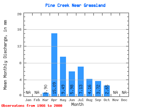
| Statistic | Jan | Feb | Mar | Apr | May | Jun | Jul | Aug | Sep | Oct | Nov | Dec | Annual |
|---|---|---|---|---|---|---|---|---|---|---|---|---|---|
| Mean | 0.58 | 9.71 | 6.11 | 3.85 | 4.59 | 2.67 | 2.40 | 1.71 | |||||
| Standard Deviation | 0.87 | 13.61 | 9.22 | 6.28 | 6.94 | 3.66 | 4.73 | 2.80 | |||||
| Min | 0.00 | 0.05 | 0.06 | 0.02 | 0.00 | 0.00 | 0.00 | 0.00 | |||||
| Max | 3.69 | 58.99 | 33.80 | 33.43 | 32.88 | 13.52 | 24.49 | 13.56 | |||||
| Coefficient of Variation | 1.50 | 1.40 | 1.51 | 1.63 | 1.51 | 1.37 | 1.97 | 1.64 |
 Return to R-Arctic Net Home Page