|
|
|||||||||||||||||
| Point ID: 6849 | Downloads | Plots | Site Data | Code: 10453 |
|
|
|||||||||||||||||
| Download | |
|---|---|
| Site Descriptor Information | Site Time Series Data |
| Link to all available data | |
| View: | Time Series | All |
| Units: | m3/s |
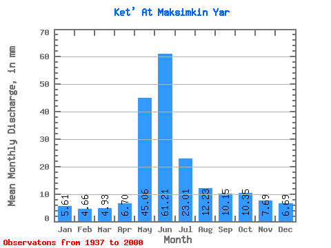
| Statistic | Jan | Feb | Mar | Apr | May | Jun | Jul | Aug | Sep | Oct | Nov | Dec | Annual |
|---|---|---|---|---|---|---|---|---|---|---|---|---|---|
| Mean | 5.61 | 4.70 | 4.93 | 6.70 | 45.05 | 61.21 | 23.01 | 12.23 | 10.15 | 10.35 | 7.69 | 6.69 | 198.00 |
| Standard Deviation | 1.53 | 1.19 | 1.27 | 2.44 | 11.90 | 22.00 | 9.35 | 4.35 | 3.89 | 3.85 | 2.33 | 2.06 | 38.65 |
| Min | 3.49 | 3.01 | 2.61 | 3.40 | 23.08 | 19.51 | 9.62 | 7.67 | 5.98 | 6.17 | 3.33 | 3.72 | 132.11 |
| Max | 14.09 | 11.06 | 11.30 | 15.79 | 76.71 | 113.40 | 50.70 | 36.27 | 28.96 | 22.80 | 14.78 | 17.02 | 321.40 |
| Coefficient of Variation | 0.27 | 0.25 | 0.26 | 0.36 | 0.26 | 0.36 | 0.41 | 0.35 | 0.38 | 0.37 | 0.30 | 0.31 | 0.20 |
 Return to R-Arctic Net Home Page