|
|
|||||||||||||||||
| Point ID: 6847 | Downloads | Plots | Site Data | Code: 10445 |
|
|
|||||||||||||||||
| Download | |
|---|---|
| Site Descriptor Information | Site Time Series Data |
| Link to all available data | |
| View: | Time Series | All |
| Units: | m3/s |
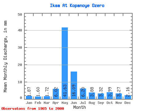
| Statistic | Jan | Feb | Mar | Apr | May | Jun | Jul | Aug | Sep | Oct | Nov | Dec | Annual |
|---|---|---|---|---|---|---|---|---|---|---|---|---|---|
| Mean | 1.86 | 1.61 | 1.72 | 6.02 | 41.62 | 16.09 | 6.20 | 3.88 | 3.32 | 3.98 | 3.27 | 2.15 | 91.18 |
| Standard Deviation | 0.46 | 0.31 | 0.26 | 4.84 | 30.54 | 12.95 | 7.08 | 3.31 | 2.08 | 2.47 | 2.10 | 0.73 | 51.01 |
| Min | 1.29 | 1.03 | 1.13 | 1.22 | 5.35 | 2.47 | 1.64 | 1.47 | 1.52 | 1.60 | 1.33 | 1.18 | 29.78 |
| Max | 3.20 | 2.36 | 2.26 | 24.28 | 114.62 | 51.24 | 38.50 | 16.35 | 9.35 | 10.18 | 9.70 | 4.11 | 217.89 |
| Coefficient of Variation | 0.24 | 0.19 | 0.15 | 0.80 | 0.73 | 0.81 | 1.14 | 0.85 | 0.63 | 0.62 | 0.64 | 0.34 | 0.56 |
 Return to R-Arctic Net Home Page