|
|
|||||||||||||||||
| Point ID: 6834 | Downloads | Plots | Site Data | Code: 10422 |
|
|
|||||||||||||||||
| Download | |
|---|---|
| Site Descriptor Information | Site Time Series Data |
| Link to all available data | |
| View: | Time Series | All |
| Units: | m3/s |
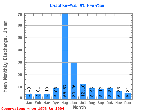
| Statistic | Jan | Feb | Mar | Apr | May | Jun | Jul | Aug | Sep | Oct | Nov | Dec | Annual |
|---|---|---|---|---|---|---|---|---|---|---|---|---|---|
| Mean | 4.49 | 3.85 | 4.10 | 9.03 | 69.86 | 30.26 | 12.10 | 8.96 | 8.12 | 8.86 | 6.83 | 5.21 | 172.38 |
| Standard Deviation | 1.26 | 1.13 | 1.32 | 6.04 | 22.76 | 16.42 | 5.40 | 2.85 | 2.64 | 3.35 | 2.17 | 1.59 | 39.65 |
| Min | 2.12 | 2.03 | 1.81 | 2.31 | 24.77 | 9.60 | 5.65 | 5.11 | 4.80 | 5.19 | 3.30 | 2.97 | 93.15 |
| Max | 7.09 | 6.60 | 7.76 | 25.87 | 126.45 | 67.16 | 31.97 | 16.14 | 14.13 | 22.31 | 12.64 | 9.46 | 237.39 |
| Coefficient of Variation | 0.28 | 0.29 | 0.32 | 0.67 | 0.33 | 0.54 | 0.45 | 0.32 | 0.33 | 0.38 | 0.32 | 0.31 | 0.23 |
 Return to R-Arctic Net Home Page