|
|
|||||||||||||||||
| Point ID: 683 | Downloads | Plots | Site Data | Code: 07CA001 |
|
|
|||||||||||||||||
| Download | |
|---|---|
| Site Descriptor Information | Site Time Series Data |
| Link to all available data | |
| View: | Time Series | All |
| Units: | m3/s |
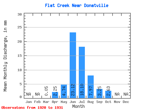
| Statistic | Jan | Feb | Mar | Apr | May | Jun | Jul | Aug | Sep | Oct | Nov | Dec | Annual |
|---|---|---|---|---|---|---|---|---|---|---|---|---|---|
| Mean | 0.04 | 1.65 | 3.48 | 16.94 | 13.26 | 5.84 | 2.38 | 1.93 | |||||
| Standard Deviation | 1.60 | 3.13 | 46.60 | 22.13 | 9.21 | 3.27 | 3.21 | ||||||
| Min | 0.04 | 0.07 | 0.47 | 0.21 | 0.05 | 0.00 | 0.00 | 0.01 | |||||
| Max | 0.04 | 4.20 | 8.44 | 149.45 | 66.75 | 28.83 | 10.12 | 10.98 | |||||
| Coefficient of Variation | 0.97 | 0.90 | 2.75 | 1.67 | 1.58 | 1.37 | 1.67 |
 Return to R-Arctic Net Home Page