|
|
|||||||||||||||||
| Point ID: 6827 | Downloads | Plots | Site Data | Code: 10408 |
|
|
|||||||||||||||||
| Download | |
|---|---|
| Site Descriptor Information | Site Time Series Data |
| Link to all available data | |
| View: | Time Series | All |
| Units: | m3/s |
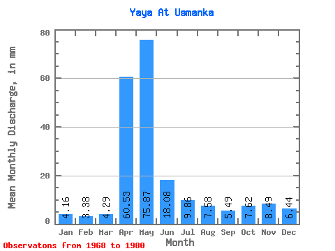
| Statistic | Jan | Feb | Mar | Apr | May | Jun | Jul | Aug | Sep | Oct | Nov | Dec | Annual |
|---|---|---|---|---|---|---|---|---|---|---|---|---|---|
| Mean | 4.15 | 3.41 | 4.29 | 60.52 | 75.86 | 18.08 | 9.86 | 7.58 | 5.49 | 7.62 | 8.49 | 6.44 | 218.59 |
| Standard Deviation | 2.34 | 1.96 | 3.40 | 36.62 | 54.64 | 15.49 | 9.51 | 2.76 | 2.25 | 3.53 | 6.08 | 4.59 | 76.47 |
| Min | 1.19 | 1.15 | 0.35 | 18.70 | 16.62 | 4.88 | 2.86 | 2.61 | 2.97 | 4.20 | 3.63 | 1.67 | 104.01 |
| Max | 9.19 | 7.66 | 9.66 | 110.54 | 188.77 | 47.27 | 33.61 | 12.47 | 9.50 | 15.25 | 23.07 | 15.41 | 322.55 |
| Coefficient of Variation | 0.56 | 0.58 | 0.79 | 0.60 | 0.72 | 0.86 | 0.96 | 0.36 | 0.41 | 0.46 | 0.72 | 0.71 | 0.35 |
 Return to R-Arctic Net Home Page