|
|
|||||||||||||||||
| Point ID: 6823 | Downloads | Plots | Site Data | Code: 10400 |
|
|
|||||||||||||||||
| Download | |
|---|---|
| Site Descriptor Information | Site Time Series Data |
| Link to all available data | |
| View: | Time Series | All |
| Units: | m3/s |
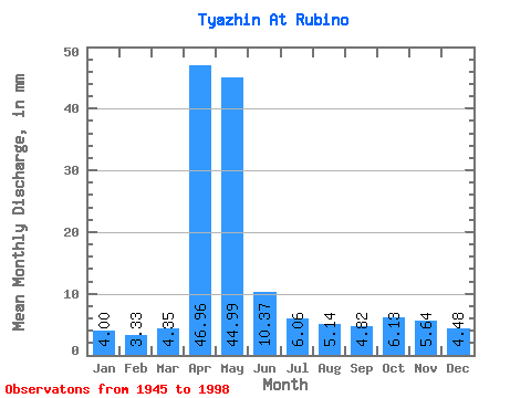
| Statistic | Jan | Feb | Mar | Apr | May | Jun | Jul | Aug | Sep | Oct | Nov | Dec | Annual |
|---|---|---|---|---|---|---|---|---|---|---|---|---|---|
| Mean | 4.00 | 3.36 | 4.35 | 46.96 | 44.99 | 10.37 | 6.06 | 5.14 | 4.81 | 6.13 | 5.64 | 4.48 | 146.20 |
| Standard Deviation | 1.37 | 1.00 | 2.12 | 24.36 | 28.62 | 5.87 | 3.61 | 1.99 | 1.71 | 2.50 | 2.22 | 1.48 | 41.78 |
| Min | 1.77 | 1.72 | 2.04 | 3.69 | 10.04 | 3.27 | 1.96 | 1.65 | 1.93 | 2.92 | 2.30 | 1.95 | 66.41 |
| Max | 7.44 | 5.38 | 13.72 | 108.14 | 127.80 | 32.98 | 26.63 | 10.65 | 8.94 | 13.29 | 12.70 | 7.97 | 249.66 |
| Coefficient of Variation | 0.34 | 0.30 | 0.49 | 0.52 | 0.64 | 0.57 | 0.59 | 0.39 | 0.35 | 0.41 | 0.39 | 0.33 | 0.29 |
 Return to R-Arctic Net Home Page