|
|
|||||||||||||||||
| Point ID: 6804 | Downloads | Plots | Site Data | Code: 10361 |
|
|
|||||||||||||||||
| Download | |
|---|---|
| Site Descriptor Information | Site Time Series Data |
| Link to all available data | |
| View: | Time Series | All |
| Units: | m3/s |
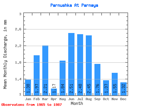
| Statistic | Jan | Feb | Mar | Apr | May | Jun | Jul | Aug | Sep | Oct | Nov | Dec | Annual |
|---|---|---|---|---|---|---|---|---|---|---|---|---|---|
| Mean | 1.38 | 1.98 | 2.21 | 1.18 | 1.84 | 2.51 | 2.48 | 2.44 | 1.76 | 1.38 | 1.55 | 1.32 | 22.54 |
| Standard Deviation | 1.73 | 1.56 | 1.54 | 2.10 | 2.79 | 2.87 | 3.27 | 3.60 | 2.12 | 1.48 | 1.51 | 1.90 | 21.36 |
| Min | 0.04 | 1.18 | 1.23 | 0.01 | 0.03 | 0.03 | 0.03 | 0.04 | 0.19 | 0.05 | 0.01 | 0.01 | 11.29 |
| Max | 6.84 | 5.76 | 5.81 | 8.31 | 12.71 | 10.87 | 14.52 | 16.91 | 8.37 | 5.61 | 5.81 | 8.26 | 65.98 |
| Coefficient of Variation | 1.25 | 0.79 | 0.70 | 1.79 | 1.52 | 1.14 | 1.32 | 1.47 | 1.20 | 1.07 | 0.98 | 1.44 | 0.95 |
 Return to R-Arctic Net Home Page