|
|
|||||||||||||||||
| Point ID: 6795 | Downloads | Plots | Site Data | Code: 10332 |
|
|
|||||||||||||||||
| Download | |
|---|---|
| Site Descriptor Information | Site Time Series Data |
| Link to all available data | |
| View: | Time Series | All |
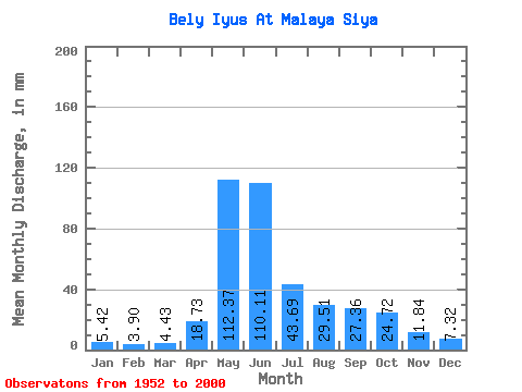
| Units: | m3/s |
| Statistic | Jan | Feb | Mar | Apr | May | Jun | Jul | Aug | Sep | Oct | Nov | Dec | Annual |
|---|---|---|---|---|---|---|---|---|---|---|---|---|---|
| Mean | 5.42 | 3.93 | 4.43 | 18.73 | 112.36 | 110.11 | 43.68 | 29.51 | 27.36 | 24.71 | 11.84 | 7.32 | 398.11 |
| Standard Deviation | 1.42 | 1.16 | 1.20 | 10.37 | 28.52 | 43.59 | 16.58 | 9.86 | 11.02 | 8.60 | 4.28 | 2.20 | 69.60 |
| Min | 2.41 | 1.43 | 2.02 | 5.85 | 24.34 | 43.37 | 17.95 | 15.29 | 13.40 | 11.87 | 5.01 | 4.12 | 265.17 |
| Max | 9.28 | 7.07 | 8.14 | 46.24 | 171.94 | 223.12 | 103.47 | 67.18 | 74.37 | 54.62 | 23.05 | 13.16 | 525.39 |
| Coefficient of Variation | 0.26 | 0.29 | 0.27 | 0.55 | 0.25 | 0.40 | 0.38 | 0.33 | 0.40 | 0.35 | 0.36 | 0.30 | 0.17 |
 Return to R-Arctic Net Home Page