|
|
|||||||||||||||||
| Point ID: 6790 | Downloads | Plots | Site Data | Other Close Sites | Code: 10323 |
|
|
|||||||||||||||||
| Download | |
|---|---|
| Site Descriptor Information | Site Time Series Data |
| Link to all available data | |
| View: | Time Series | All |
| Units: | m3/s |
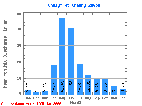
| Statistic | Jan | Feb | Mar | Apr | May | Jun | Jul | Aug | Sep | Oct | Nov | Dec | Annual |
|---|---|---|---|---|---|---|---|---|---|---|---|---|---|
| Mean | 2.67 | 1.86 | 2.06 | 18.01 | 46.42 | 40.58 | 18.30 | 12.02 | 9.76 | 9.75 | 5.41 | 3.76 | 170.41 |
| Standard Deviation | 0.74 | 0.66 | 0.89 | 9.75 | 13.90 | 13.56 | 6.71 | 4.87 | 3.79 | 3.44 | 1.83 | 1.07 | 33.80 |
| Min | 1.19 | 0.88 | 0.75 | 2.77 | 28.76 | 18.79 | 6.92 | 5.98 | 4.52 | 4.78 | 2.65 | 1.70 | 112.61 |
| Max | 4.72 | 3.91 | 5.44 | 52.84 | 117.26 | 76.69 | 36.68 | 35.34 | 26.38 | 20.68 | 10.28 | 6.02 | 254.07 |
| Coefficient of Variation | 0.28 | 0.35 | 0.43 | 0.54 | 0.30 | 0.33 | 0.37 | 0.41 | 0.39 | 0.35 | 0.34 | 0.28 | 0.20 |
| Other Close Sites | ||||||
|---|---|---|---|---|---|---|
| PointID | Latitude | Longitude | Drainage Area | Source | Name | |
| 6926 | "Chulym At Ershovo" | 55.98 | -19518 | SHI | 1282.00 | |
 Return to R-Arctic Net Home Page