|
|
|||||||||||||||||
| Point ID: 6787 | Downloads | Plots | Site Data | Code: 10310 |
|
|
|||||||||||||||||
| Download | |
|---|---|
| Site Descriptor Information | Site Time Series Data |
| Link to all available data | |
| View: | Time Series | All |
| Units: | m3/s |
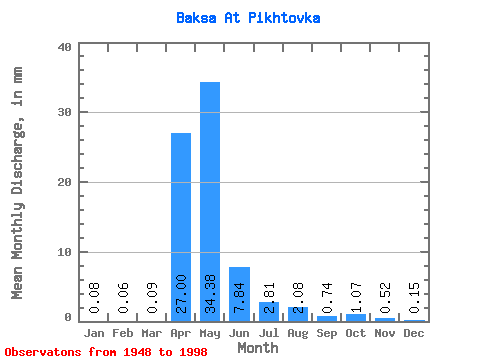
| Statistic | Jan | Feb | Mar | Apr | May | Jun | Jul | Aug | Sep | Oct | Nov | Dec | Annual |
|---|---|---|---|---|---|---|---|---|---|---|---|---|---|
| Mean | 0.09 | 0.06 | 0.09 | 27.00 | 34.38 | 7.84 | 2.81 | 2.08 | 0.74 | 1.07 | 0.52 | 0.15 | 79.37 |
| Standard Deviation | 0.19 | 0.14 | 0.18 | 34.52 | 30.97 | 8.71 | 4.68 | 4.86 | 1.33 | 1.97 | 0.95 | 0.38 | 57.08 |
| Min | 0.00 | 0.00 | 0.00 | 0.27 | 0.36 | 0.12 | 0.03 | 0.00 | 0.00 | 0.00 | 0.00 | 0.00 | 8.65 |
| Max | 0.83 | 0.64 | 0.83 | 186.19 | 109.95 | 37.97 | 27.35 | 24.89 | 6.21 | 9.17 | 4.33 | 1.75 | 223.31 |
| Coefficient of Variation | 2.21 | 2.15 | 1.95 | 1.28 | 0.90 | 1.11 | 1.67 | 2.33 | 1.80 | 1.85 | 1.83 | 2.43 | 0.72 |
 Return to R-Arctic Net Home Page