|
|
|||||||||||||||||
| Point ID: 6785 | Downloads | Plots | Site Data | Code: 10306 |
|
|
|||||||||||||||||
| Download | |
|---|---|
| Site Descriptor Information | Site Time Series Data |
| Link to all available data | |
| View: | Time Series | All |
| Units: | m3/s |
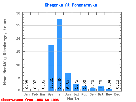
| Statistic | Jan | Feb | Mar | Apr | May | Jun | Jul | Aug | Sep | Oct | Nov | Dec | Annual |
|---|---|---|---|---|---|---|---|---|---|---|---|---|---|
| Mean | 0.06 | 0.02 | 0.05 | 17.32 | 27.48 | 6.80 | 2.76 | 2.00 | 1.20 | 1.78 | 0.84 | 0.13 | 68.98 |
| Standard Deviation | 0.12 | 0.05 | 0.07 | 18.91 | 23.91 | 7.80 | 5.71 | 3.70 | 2.12 | 2.54 | 1.31 | 0.25 | 47.10 |
| Min | 0.00 | 0.00 | 0.00 | 0.03 | 0.19 | 0.01 | 0.00 | 0.00 | 0.00 | 0.00 | 0.00 | 0.00 | 10.06 |
| Max | 0.51 | 0.19 | 0.26 | 96.07 | 94.58 | 31.47 | 31.24 | 13.77 | 7.96 | 9.10 | 5.97 | 1.00 | 166.23 |
| Coefficient of Variation | 2.17 | 2.07 | 1.63 | 1.09 | 0.87 | 1.15 | 2.07 | 1.85 | 1.76 | 1.43 | 1.56 | 1.87 | 0.68 |
 Return to R-Arctic Net Home Page