|
|
|||||||||||||||||
| Point ID: 6755 | Downloads | Plots | Site Data | Code: 10225 |
|
|
|||||||||||||||||
| Download | |
|---|---|
| Site Descriptor Information | Site Time Series Data |
| Link to all available data | |
| View: | Time Series | All |
| Units: | m3/s |
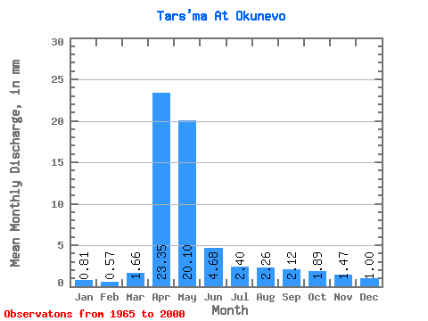
| Statistic | Jan | Feb | Mar | Apr | May | Jun | Jul | Aug | Sep | Oct | Nov | Dec | Annual |
|---|---|---|---|---|---|---|---|---|---|---|---|---|---|
| Mean | 0.81 | 0.58 | 1.66 | 23.35 | 20.10 | 4.68 | 2.40 | 2.26 | 2.12 | 1.89 | 1.47 | 1.00 | 66.63 |
| Standard Deviation | 0.63 | 0.57 | 1.72 | 15.58 | 13.33 | 3.20 | 1.80 | 1.70 | 1.32 | 1.06 | 0.67 | 0.52 | 32.77 |
| Min | 0.00 | 0.00 | 0.04 | 6.80 | 2.32 | 0.68 | 0.12 | 0.46 | 0.55 | 0.61 | 0.36 | 0.09 | 25.55 |
| Max | 2.77 | 2.83 | 7.33 | 81.07 | 50.44 | 12.25 | 8.03 | 9.03 | 6.42 | 5.50 | 3.04 | 1.98 | 164.70 |
| Coefficient of Variation | 0.78 | 0.98 | 1.03 | 0.67 | 0.66 | 0.68 | 0.75 | 0.75 | 0.62 | 0.56 | 0.46 | 0.52 | 0.49 |
 Return to R-Arctic Net Home Page