|
|
|||||||||||||||||
| Point ID: 6752 | Downloads | Plots | Site Data | Other Close Sites | Code: 10220 |
|
|
|||||||||||||||||
| Download | |
|---|---|
| Site Descriptor Information | Site Time Series Data |
| Link to all available data | |
| View: | Time Series | All |
| Units: | m3/s |
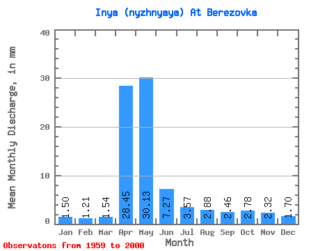
| Statistic | Jan | Feb | Mar | Apr | May | Jun | Jul | Aug | Sep | Oct | Nov | Dec | Annual |
|---|---|---|---|---|---|---|---|---|---|---|---|---|---|
| Mean | 1.50 | 1.22 | 1.54 | 28.45 | 30.12 | 7.27 | 3.57 | 2.88 | 2.46 | 2.78 | 2.32 | 1.70 | 86.51 |
| Standard Deviation | 0.64 | 0.59 | 0.84 | 12.10 | 17.54 | 4.11 | 1.50 | 1.29 | 1.01 | 1.17 | 0.95 | 0.69 | 24.75 |
| Min | 0.34 | 0.37 | 0.43 | 10.67 | 8.48 | 2.55 | 0.84 | 1.19 | 0.84 | 1.00 | 0.87 | 0.57 | 45.79 |
| Max | 2.66 | 2.57 | 4.50 | 65.92 | 85.45 | 20.08 | 7.18 | 6.30 | 5.30 | 5.45 | 4.25 | 3.79 | 138.74 |
| Coefficient of Variation | 0.43 | 0.49 | 0.55 | 0.42 | 0.58 | 0.56 | 0.42 | 0.45 | 0.41 | 0.42 | 0.41 | 0.41 | 0.29 |
| Other Close Sites | ||||||
|---|---|---|---|---|---|---|
| PointID | Latitude | Longitude | Drainage Area | Source | Name | |
| 6660 | "Ob At HPS Novosibirskaya" | 54.80 | -472892 | SHI | 2986.00 | |
| 6661 | "Ob At Novosibirsk" | 55.00 | -470289 | SHI | 2963.00 | |
 Return to R-Arctic Net Home Page