|
|
|||||||||||||||||
| Point ID: 6747 | Downloads | Plots | Site Data | Code: 10211 |
|
|
|||||||||||||||||
| Download | |
|---|---|
| Site Descriptor Information | Site Time Series Data |
| Link to all available data | |
| View: | Time Series | All |
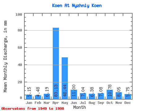
| Units: | m3/s |
| Statistic | Jan | Feb | Mar | Apr | May | Jun | Jul | Aug | Sep | Oct | Nov | Dec | Annual |
|---|---|---|---|---|---|---|---|---|---|---|---|---|---|
| Mean | 5.14 | 4.52 | 6.19 | 83.13 | 48.43 | 11.00 | 7.05 | 6.38 | 7.07 | 10.78 | 8.06 | 5.75 | 202.15 |
| Standard Deviation | 2.28 | 1.92 | 3.52 | 34.17 | 31.95 | 4.80 | 4.27 | 4.30 | 4.04 | 4.43 | 3.86 | 2.51 | 52.68 |
| Min | 0.39 | 1.63 | 1.29 | 24.00 | 13.89 | 3.46 | 1.29 | 1.39 | 1.92 | 4.56 | 3.07 | 0.32 | 107.05 |
| Max | 9.22 | 9.04 | 18.45 | 195.84 | 130.92 | 24.58 | 21.52 | 26.09 | 21.79 | 21.23 | 21.22 | 10.41 | 327.29 |
| Coefficient of Variation | 0.44 | 0.42 | 0.57 | 0.41 | 0.66 | 0.44 | 0.61 | 0.68 | 0.57 | 0.41 | 0.48 | 0.44 | 0.26 |
 Return to R-Arctic Net Home Page