|
|
|||||||||||||||||
| Point ID: 6746 | Downloads | Plots | Site Data | Code: 10210 |
|
|
|||||||||||||||||
| Download | |
|---|---|
| Site Descriptor Information | Site Time Series Data |
| Link to all available data | |
| View: | Time Series | All |
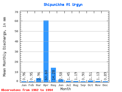
| Units: | m3/s |
| Statistic | Jan | Feb | Mar | Apr | May | Jun | Jul | Aug | Sep | Oct | Nov | Dec | Annual |
|---|---|---|---|---|---|---|---|---|---|---|---|---|---|
| Mean | 0.95 | 0.95 | 3.96 | 60.60 | 14.27 | 2.58 | 1.45 | 1.19 | 0.90 | 1.51 | 1.13 | 0.89 | 93.61 |
| Standard Deviation | 0.59 | 0.74 | 6.26 | 23.80 | 11.26 | 1.83 | 1.52 | 0.81 | 0.57 | 1.09 | 0.85 | 0.69 | 33.77 |
| Min | 0.04 | 0.07 | 0.30 | 23.73 | 3.57 | 0.47 | 0.18 | 0.23 | 0.21 | 0.23 | 0.05 | 0.07 | 53.85 |
| Max | 1.93 | 2.63 | 25.76 | 121.65 | 46.20 | 8.49 | 8.61 | 3.57 | 2.41 | 4.87 | 3.18 | 2.49 | 167.42 |
| Coefficient of Variation | 0.62 | 0.78 | 1.58 | 0.39 | 0.79 | 0.71 | 1.04 | 0.68 | 0.64 | 0.72 | 0.75 | 0.78 | 0.36 |
 Return to R-Arctic Net Home Page