|
|
|||||||||||||||||
| Point ID: 6741 | Downloads | Plots | Site Data | Code: 10202 |
|
|
|||||||||||||||||
| Download | |
|---|---|
| Site Descriptor Information | Site Time Series Data |
| Link to all available data | |
| View: | Time Series | All |
| Units: | m3/s |
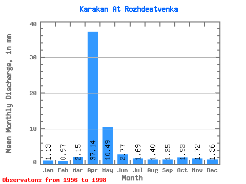
| Statistic | Jan | Feb | Mar | Apr | May | Jun | Jul | Aug | Sep | Oct | Nov | Dec | Annual |
|---|---|---|---|---|---|---|---|---|---|---|---|---|---|
| Mean | 1.12 | 0.98 | 2.15 | 37.14 | 10.48 | 2.77 | 1.69 | 1.40 | 1.35 | 1.93 | 1.72 | 1.35 | 64.11 |
| Standard Deviation | 0.58 | 0.48 | 3.60 | 22.13 | 7.57 | 1.39 | 0.97 | 0.75 | 0.69 | 1.04 | 1.01 | 0.64 | 30.69 |
| Min | 0.05 | 0.16 | 0.35 | 8.73 | 2.61 | 0.80 | 0.63 | 0.49 | 0.55 | 0.82 | 0.48 | 0.33 | 26.44 |
| Max | 2.49 | 2.25 | 23.73 | 90.95 | 31.48 | 7.48 | 5.21 | 4.60 | 3.87 | 5.64 | 5.28 | 2.98 | 139.55 |
| Coefficient of Variation | 0.51 | 0.49 | 1.68 | 0.60 | 0.72 | 0.50 | 0.58 | 0.53 | 0.52 | 0.54 | 0.59 | 0.47 | 0.48 |
 Return to R-Arctic Net Home Page