|
|
|||||||||||||||||
| Point ID: 6736 | Downloads | Plots | Site Data | Code: 10189 |
|
|
|||||||||||||||||
| Download | |
|---|---|
| Site Descriptor Information | Site Time Series Data |
| Link to all available data | |
| View: | Time Series | All |
| Units: | m3/s |
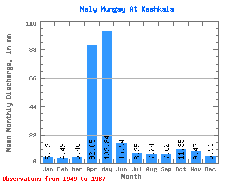
| Statistic | Jan | Feb | Mar | Apr | May | Jun | Jul | Aug | Sep | Oct | Nov | Dec | Annual |
|---|---|---|---|---|---|---|---|---|---|---|---|---|---|
| Mean | 5.12 | 4.47 | 5.46 | 92.04 | 102.82 | 15.92 | 8.25 | 7.23 | 7.63 | 11.35 | 9.46 | 5.91 | 278.01 |
| Standard Deviation | 1.92 | 1.66 | 2.08 | 52.45 | 69.54 | 11.31 | 5.17 | 3.68 | 3.74 | 5.92 | 7.96 | 2.00 | 72.78 |
| Min | 1.80 | 1.33 | 1.86 | 11.04 | 16.97 | 3.85 | 3.45 | 1.78 | 2.57 | 3.98 | 2.26 | 2.07 | 166.91 |
| Max | 9.81 | 8.94 | 10.61 | 223.53 | 310.22 | 47.48 | 33.94 | 19.09 | 17.19 | 33.41 | 52.35 | 10.34 | 467.23 |
| Coefficient of Variation | 0.38 | 0.37 | 0.38 | 0.57 | 0.68 | 0.71 | 0.63 | 0.51 | 0.49 | 0.52 | 0.84 | 0.34 | 0.26 |
 Return to R-Arctic Net Home Page