|
|
|||||||||||||||||
| Point ID: 6735 | Downloads | Plots | Site Data | Code: 10188 |
|
|
|||||||||||||||||
| Download | |
|---|---|
| Site Descriptor Information | Site Time Series Data |
| Link to all available data | |
| View: | Time Series | All |
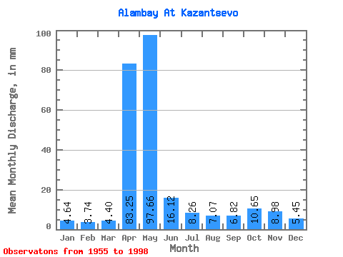
| Units: | m3/s |
| Statistic | Jan | Feb | Mar | Apr | May | Jun | Jul | Aug | Sep | Oct | Nov | Dec | Annual |
|---|---|---|---|---|---|---|---|---|---|---|---|---|---|
| Mean | 4.64 | 3.78 | 4.40 | 83.25 | 97.64 | 16.12 | 8.26 | 7.07 | 6.82 | 10.65 | 8.98 | 5.45 | 258.96 |
| Standard Deviation | 1.77 | 1.41 | 1.76 | 42.21 | 66.58 | 11.40 | 4.10 | 2.76 | 3.27 | 5.26 | 6.92 | 2.33 | 68.82 |
| Min | 1.38 | 1.20 | 1.02 | 9.67 | 17.28 | 5.35 | 2.83 | 2.44 | 3.28 | 4.45 | 2.93 | 1.41 | 155.19 |
| Max | 8.28 | 6.64 | 10.56 | 187.20 | 258.50 | 51.66 | 27.71 | 14.56 | 17.21 | 27.71 | 44.10 | 14.36 | 414.54 |
| Coefficient of Variation | 0.38 | 0.37 | 0.40 | 0.51 | 0.68 | 0.71 | 0.50 | 0.39 | 0.48 | 0.49 | 0.77 | 0.43 | 0.27 |
 Return to R-Arctic Net Home Page