|
|
|||||||||||||||||
| Point ID: 6734 | Downloads | Plots | Site Data | Code: 10187 |
|
|
|||||||||||||||||
| Download | |
|---|---|
| Site Descriptor Information | Site Time Series Data |
| Link to all available data | |
| View: | Time Series | All |
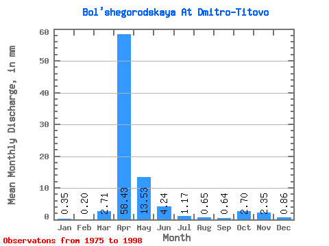
| Units: | m3/s |
| Statistic | Jan | Feb | Mar | Apr | May | Jun | Jul | Aug | Sep | Oct | Nov | Dec | Annual |
|---|---|---|---|---|---|---|---|---|---|---|---|---|---|
| Mean | 0.34 | 0.21 | 2.71 | 58.43 | 13.52 | 4.24 | 1.17 | 0.65 | 0.64 | 2.70 | 2.36 | 0.86 | 89.25 |
| Standard Deviation | 0.59 | 0.45 | 4.90 | 20.54 | 4.28 | 3.24 | 0.97 | 0.77 | 0.71 | 1.83 | 1.18 | 0.78 | 22.77 |
| Min | 0.00 | 0.00 | 0.00 | 21.92 | 4.13 | 0.05 | 0.16 | 0.00 | 0.00 | 0.00 | 0.00 | 0.00 | 43.75 |
| Max | 1.90 | 1.32 | 16.40 | 97.63 | 21.76 | 12.74 | 2.90 | 2.68 | 2.38 | 5.69 | 4.64 | 2.46 | 120.77 |
| Coefficient of Variation | 1.73 | 2.14 | 1.81 | 0.35 | 0.32 | 0.76 | 0.83 | 1.20 | 1.11 | 0.68 | 0.50 | 0.90 | 0.26 |
 Return to R-Arctic Net Home Page