|
|
|||||||||||||||||
| Point ID: 6730 | Downloads | Plots | Site Data | Code: 10177 |
|
|
|||||||||||||||||
| Download | |
|---|---|
| Site Descriptor Information | Site Time Series Data |
| Link to all available data | |
| View: | Time Series | All |
| Units: | m3/s |
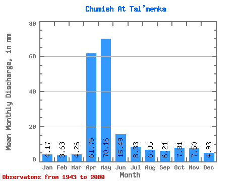
| Statistic | Jan | Feb | Mar | Apr | May | Jun | Jul | Aug | Sep | Oct | Nov | Dec | Annual |
|---|---|---|---|---|---|---|---|---|---|---|---|---|---|
| Mean | 4.17 | 3.66 | 4.26 | 61.75 | 70.15 | 15.49 | 8.32 | 6.84 | 6.21 | 7.81 | 7.50 | 4.93 | 200.82 |
| Standard Deviation | 1.33 | 1.12 | 2.04 | 26.02 | 39.08 | 9.62 | 3.62 | 3.27 | 2.51 | 2.98 | 5.13 | 2.30 | 50.74 |
| Min | 1.89 | 1.46 | 2.34 | 8.98 | 17.55 | 5.59 | 3.42 | 2.81 | 2.96 | 3.38 | 3.04 | 2.38 | 118.92 |
| Max | 8.58 | 8.08 | 17.03 | 127.08 | 191.10 | 55.49 | 21.19 | 17.16 | 13.59 | 17.29 | 36.11 | 15.34 | 340.36 |
| Coefficient of Variation | 0.32 | 0.30 | 0.48 | 0.42 | 0.56 | 0.62 | 0.43 | 0.48 | 0.40 | 0.38 | 0.68 | 0.47 | 0.25 |
 Return to R-Arctic Net Home Page