|
|
|||||||||||||||||
| Point ID: 6727 | Downloads | Plots | Site Data | Code: 10174 |
|
|
|||||||||||||||||
| Download | |
|---|---|
| Site Descriptor Information | Site Time Series Data |
| Link to all available data | |
| View: | Time Series | All |
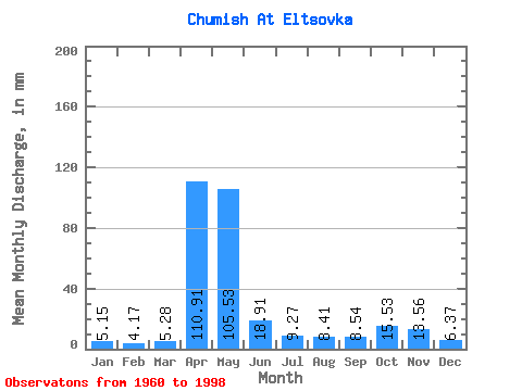
| Units: | m3/s |
| Statistic | Jan | Feb | Mar | Apr | May | Jun | Jul | Aug | Sep | Oct | Nov | Dec | Annual |
|---|---|---|---|---|---|---|---|---|---|---|---|---|---|
| Mean | 5.15 | 4.21 | 5.28 | 110.91 | 105.51 | 18.91 | 9.27 | 8.41 | 8.54 | 15.53 | 13.56 | 6.37 | 311.40 |
| Standard Deviation | 1.61 | 1.25 | 1.78 | 45.83 | 74.92 | 12.27 | 4.81 | 5.12 | 4.83 | 9.26 | 13.63 | 3.09 | 77.20 |
| Min | 1.63 | 1.16 | 2.29 | 39.18 | 22.46 | 5.88 | 3.87 | 3.56 | 3.29 | 4.21 | 4.29 | 1.58 | 176.65 |
| Max | 9.01 | 6.97 | 11.11 | 233.52 | 360.98 | 51.36 | 26.90 | 30.79 | 27.05 | 41.53 | 83.61 | 16.35 | 508.00 |
| Coefficient of Variation | 0.31 | 0.30 | 0.34 | 0.41 | 0.71 | 0.65 | 0.52 | 0.61 | 0.56 | 0.60 | 1.00 | 0.49 | 0.25 |
 Return to R-Arctic Net Home Page