|
|
|||||||||||||||||
| Point ID: 6726 | Downloads | Plots | Site Data | Code: 10172 |
|
|
|||||||||||||||||
| Download | |
|---|---|
| Site Descriptor Information | Site Time Series Data |
| Link to all available data | |
| View: | Time Series | All |
| Units: | m3/s |
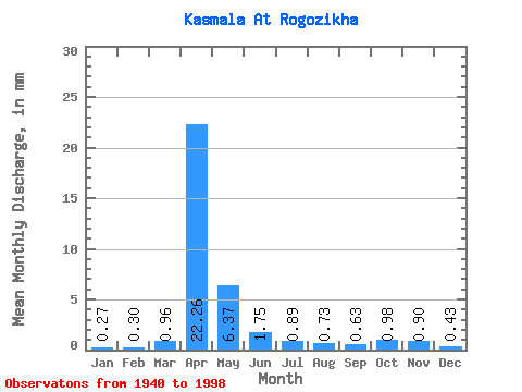
| Statistic | Jan | Feb | Mar | Apr | May | Jun | Jul | Aug | Sep | Oct | Nov | Dec | Annual |
|---|---|---|---|---|---|---|---|---|---|---|---|---|---|
| Mean | 0.27 | 0.30 | 0.96 | 22.26 | 6.37 | 1.75 | 0.89 | 0.73 | 0.63 | 0.98 | 0.90 | 0.43 | 39.98 |
| Standard Deviation | 0.24 | 0.39 | 1.25 | 12.27 | 4.83 | 1.10 | 0.49 | 0.45 | 0.41 | 0.63 | 0.65 | 0.32 | 16.70 |
| Min | 0.00 | 0.00 | 0.00 | 4.08 | 1.44 | 0.52 | 0.33 | 0.29 | 0.24 | 0.29 | 0.04 | 0.00 | 11.76 |
| Max | 1.09 | 2.16 | 5.58 | 54.35 | 27.27 | 7.26 | 2.21 | 2.11 | 2.45 | 3.65 | 3.08 | 1.25 | 76.44 |
| Coefficient of Variation | 0.89 | 1.29 | 1.30 | 0.55 | 0.76 | 0.63 | 0.55 | 0.61 | 0.65 | 0.65 | 0.72 | 0.74 | 0.42 |
 Return to R-Arctic Net Home Page