|
|
|||||||||||||||||
| Point ID: 6720 | Downloads | Plots | Site Data | Code: 10148 |
|
|
|||||||||||||||||
| Download | |
|---|---|
| Site Descriptor Information | Site Time Series Data |
| Link to all available data | |
| View: | Time Series | All |
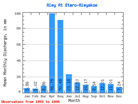
| Units: | m3/s |
| Statistic | Jan | Feb | Mar | Apr | May | Jun | Jul | Aug | Sep | Oct | Nov | Dec | Annual |
|---|---|---|---|---|---|---|---|---|---|---|---|---|---|
| Mean | 5.86 | 5.07 | 8.86 | 98.79 | 90.46 | 23.18 | 12.56 | 10.17 | 8.54 | 12.01 | 11.01 | 7.24 | 294.00 |
| Standard Deviation | 2.71 | 2.64 | 7.68 | 35.88 | 49.78 | 15.01 | 6.97 | 5.69 | 3.18 | 4.97 | 4.60 | 3.22 | 86.47 |
| Min | 1.03 | 0.88 | 1.38 | 8.69 | 18.37 | 7.68 | 4.76 | 3.80 | 4.62 | 5.19 | 4.32 | 2.13 | 164.41 |
| Max | 13.46 | 14.97 | 46.57 | 174.05 | 245.81 | 75.38 | 37.00 | 31.95 | 17.66 | 26.65 | 21.16 | 14.88 | 527.18 |
| Coefficient of Variation | 0.46 | 0.52 | 0.87 | 0.36 | 0.55 | 0.65 | 0.56 | 0.56 | 0.37 | 0.41 | 0.42 | 0.45 | 0.29 |
 Return to R-Arctic Net Home Page