|
|
|||||||||||||||||
| Point ID: 6715 | Downloads | Plots | Site Data | Other Close Sites | Code: 10134 |
|
|
|||||||||||||||||
| Download | |
|---|---|
| Site Descriptor Information | Site Time Series Data |
| Link to all available data | |
| View: | Time Series | All |
| Units: | m3/s |
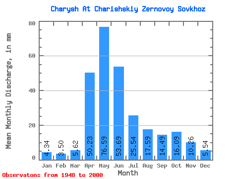
| Statistic | Jan | Feb | Mar | Apr | May | Jun | Jul | Aug | Sep | Oct | Nov | Dec | Annual |
|---|---|---|---|---|---|---|---|---|---|---|---|---|---|
| Mean | 4.34 | 3.53 | 5.62 | 50.23 | 76.58 | 53.69 | 25.53 | 17.58 | 14.49 | 16.08 | 10.26 | 5.54 | 282.93 |
| Standard Deviation | 1.48 | 1.18 | 3.42 | 19.42 | 22.09 | 23.38 | 11.09 | 9.09 | 6.47 | 7.80 | 5.76 | 2.34 | 76.72 |
| Min | 1.63 | 1.15 | 1.42 | 8.83 | 25.87 | 13.77 | 7.01 | 4.27 | 2.84 | 5.65 | 3.07 | 1.81 | 95.28 |
| Max | 8.31 | 5.88 | 19.79 | 87.90 | 164.30 | 110.07 | 65.59 | 42.43 | 30.93 | 41.27 | 30.80 | 14.10 | 515.49 |
| Coefficient of Variation | 0.34 | 0.33 | 0.61 | 0.39 | 0.29 | 0.43 | 0.43 | 0.52 | 0.45 | 0.48 | 0.56 | 0.42 | 0.27 |
| Other Close Sites | ||||||
|---|---|---|---|---|---|---|
| PointID | Latitude | Longitude | Drainage Area | Source | Name | |
| 6714 | "Charysh At Ust'-Kamushenka" | 52.07 | -490332 | SHI | 96.00 | |
 Return to R-Arctic Net Home Page