|
|
|||||||||||||||||
| Point ID: 6713 | Downloads | Plots | Site Data | Code: 10132 |
|
|
|||||||||||||||||
| Download | |
|---|---|
| Site Descriptor Information | Site Time Series Data |
| Link to all available data | |
| View: | Time Series | All |
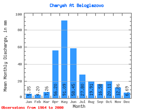
| Units: | m3/s |
| Statistic | Jan | Feb | Mar | Apr | May | Jun | Jul | Aug | Sep | Oct | Nov | Dec | Annual |
|---|---|---|---|---|---|---|---|---|---|---|---|---|---|
| Mean | 5.35 | 4.24 | 7.26 | 56.20 | 91.08 | 58.45 | 27.80 | 19.91 | 16.58 | 20.10 | 12.86 | 6.69 | 327.03 |
| Standard Deviation | 1.35 | 0.91 | 4.70 | 15.58 | 25.09 | 26.27 | 9.13 | 8.46 | 6.98 | 8.83 | 5.63 | 2.29 | 67.18 |
| Min | 3.03 | 2.55 | 3.32 | 29.16 | 49.30 | 23.56 | 11.93 | 8.08 | 7.73 | 7.88 | 4.67 | 3.88 | 205.84 |
| Max | 9.37 | 6.07 | 29.82 | 92.78 | 167.38 | 117.82 | 47.93 | 47.78 | 40.50 | 43.21 | 33.28 | 13.07 | 501.69 |
| Coefficient of Variation | 0.25 | 0.22 | 0.65 | 0.28 | 0.28 | 0.45 | 0.33 | 0.42 | 0.42 | 0.44 | 0.44 | 0.34 | 0.20 |
 Return to R-Arctic Net Home Page