|
|
|||||||||||||||||
| Point ID: 6711 | Downloads | Plots | Site Data | Code: 10127 |
|
|
|||||||||||||||||
| Download | |
|---|---|
| Site Descriptor Information | Site Time Series Data |
| Link to all available data | |
| View: | Time Series | All |
| Units: | m3/s |
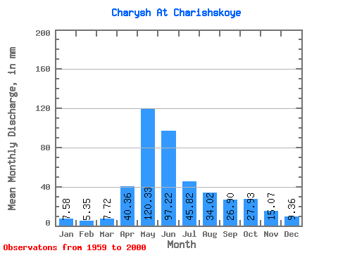
| Statistic | Jan | Feb | Mar | Apr | May | Jun | Jul | Aug | Sep | Oct | Nov | Dec | Annual |
|---|---|---|---|---|---|---|---|---|---|---|---|---|---|
| Mean | 7.58 | 5.40 | 7.71 | 40.35 | 120.31 | 97.22 | 45.82 | 34.01 | 26.90 | 27.93 | 15.07 | 9.35 | 435.07 |
| Standard Deviation | 2.83 | 2.03 | 3.15 | 14.07 | 24.43 | 41.83 | 15.20 | 15.98 | 11.94 | 13.00 | 5.45 | 3.58 | 86.40 |
| Min | 3.05 | 1.12 | 4.29 | 17.73 | 58.56 | 37.18 | 20.22 | 12.31 | 11.70 | 12.57 | 6.21 | 3.41 | 274.69 |
| Max | 13.80 | 10.64 | 17.72 | 75.09 | 161.87 | 183.75 | 72.36 | 82.06 | 62.81 | 59.68 | 26.50 | 18.35 | 580.83 |
| Coefficient of Variation | 0.37 | 0.38 | 0.41 | 0.35 | 0.20 | 0.43 | 0.33 | 0.47 | 0.44 | 0.47 | 0.36 | 0.38 | 0.20 |
 Return to R-Arctic Net Home Page