|
|
|||||||||||||||||
| Point ID: 6710 | Downloads | Plots | Site Data | Code: 10126 |
|
|
|||||||||||||||||
| Download | |
|---|---|
| Site Descriptor Information | Site Time Series Data |
| Link to all available data | |
| View: | Time Series | All |
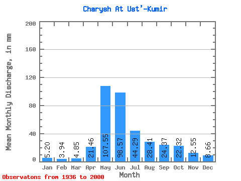
| Units: | m3/s |
| Statistic | Jan | Feb | Mar | Apr | May | Jun | Jul | Aug | Sep | Oct | Nov | Dec | Annual |
|---|---|---|---|---|---|---|---|---|---|---|---|---|---|
| Mean | 5.20 | 3.98 | 4.85 | 21.46 | 107.54 | 98.57 | 44.28 | 28.41 | 24.37 | 22.32 | 12.55 | 8.66 | 381.83 |
| Standard Deviation | 2.04 | 1.39 | 1.81 | 10.62 | 30.68 | 45.40 | 21.03 | 13.29 | 13.26 | 10.04 | 4.60 | 3.72 | 101.45 |
| Min | 0.61 | 1.38 | 1.91 | 3.98 | 56.95 | 23.76 | 11.23 | 7.68 | 6.20 | 7.22 | 3.97 | 3.00 | 178.79 |
| Max | 9.62 | 7.64 | 11.47 | 57.43 | 215.47 | 229.41 | 128.51 | 67.41 | 87.89 | 55.33 | 26.74 | 21.09 | 630.53 |
| Coefficient of Variation | 0.39 | 0.35 | 0.37 | 0.49 | 0.28 | 0.46 | 0.47 | 0.47 | 0.54 | 0.45 | 0.37 | 0.43 | 0.27 |
 Return to R-Arctic Net Home Page