|
|
|||||||||||||||||
| Point ID: 6709 | Downloads | Plots | Site Data | Code: 10123 |
|
|
|||||||||||||||||
| Download | |
|---|---|
| Site Descriptor Information | Site Time Series Data |
| Link to all available data | |
| View: | Time Series | All |
| Units: | m3/s |
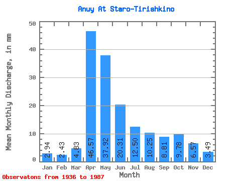
| Statistic | Jan | Feb | Mar | Apr | May | Jun | Jul | Aug | Sep | Oct | Nov | Dec | Annual |
|---|---|---|---|---|---|---|---|---|---|---|---|---|---|
| Mean | 2.94 | 2.45 | 4.83 | 46.57 | 37.91 | 20.31 | 12.50 | 10.25 | 8.81 | 9.78 | 6.57 | 3.49 | 166.34 |
| Standard Deviation | 1.62 | 1.22 | 3.38 | 21.36 | 18.33 | 9.46 | 6.48 | 5.57 | 4.40 | 4.55 | 3.98 | 2.28 | 55.76 |
| Min | 1.09 | 0.94 | 1.08 | 15.44 | 14.00 | 5.68 | 4.46 | 3.84 | 3.78 | 3.60 | 0.84 | 0.81 | 61.31 |
| Max | 9.70 | 7.30 | 17.24 | 98.76 | 89.53 | 48.06 | 35.15 | 27.41 | 23.69 | 22.99 | 18.24 | 12.31 | 332.76 |
| Coefficient of Variation | 0.55 | 0.50 | 0.70 | 0.46 | 0.48 | 0.47 | 0.52 | 0.54 | 0.50 | 0.47 | 0.61 | 0.65 | 0.34 |
 Return to R-Arctic Net Home Page