|
|
|||||||||||||||||
| Point ID: 6708 | Downloads | Plots | Site Data | Code: 10122 |
|
|
|||||||||||||||||
| Download | |
|---|---|
| Site Descriptor Information | Site Time Series Data |
| Link to all available data | |
| View: | Time Series | All |
| Units: | m3/s |
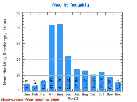
| Statistic | Jan | Feb | Mar | Apr | May | Jun | Jul | Aug | Sep | Oct | Nov | Dec | Annual |
|---|---|---|---|---|---|---|---|---|---|---|---|---|---|
| Mean | 4.49 | 3.50 | 6.48 | 41.97 | 42.27 | 22.22 | 13.94 | 12.99 | 10.57 | 12.14 | 8.97 | 5.50 | 184.77 |
| Standard Deviation | 1.45 | 1.19 | 3.31 | 14.00 | 19.36 | 9.62 | 5.54 | 7.97 | 3.95 | 5.20 | 3.78 | 1.89 | 45.35 |
| Min | 1.77 | 1.05 | 2.00 | 20.49 | 19.36 | 8.25 | 3.82 | 4.59 | 4.82 | 6.27 | 3.85 | 2.19 | 102.11 |
| Max | 7.92 | 6.31 | 14.79 | 77.17 | 108.33 | 46.62 | 28.10 | 40.91 | 22.94 | 26.95 | 23.47 | 10.56 | 321.82 |
| Coefficient of Variation | 0.32 | 0.34 | 0.51 | 0.33 | 0.46 | 0.43 | 0.40 | 0.61 | 0.37 | 0.43 | 0.42 | 0.34 | 0.24 |
 Return to R-Arctic Net Home Page