|
|
|||||||||||||||||
| Point ID: 6703 | Downloads | Plots | Site Data | Code: 10112 |
|
|
|||||||||||||||||
| Download | |
|---|---|
| Site Descriptor Information | Site Time Series Data |
| Link to all available data | |
| View: | Time Series | All |
| Units: | m3/s |
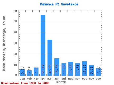
| Statistic | Jan | Feb | Mar | Apr | May | Jun | Jul | Aug | Sep | Oct | Nov | Dec | Annual |
|---|---|---|---|---|---|---|---|---|---|---|---|---|---|
| Mean | 6.16 | 5.19 | 7.56 | 55.47 | 32.95 | 15.98 | 11.55 | 12.83 | 11.61 | 13.16 | 9.91 | 7.05 | 189.55 |
| Standard Deviation | 1.76 | 1.68 | 3.02 | 23.55 | 18.11 | 6.72 | 4.12 | 7.17 | 4.68 | 5.07 | 3.21 | 2.41 | 56.44 |
| Min | 3.45 | 3.24 | 4.20 | 19.78 | 14.29 | 7.09 | 6.25 | 5.85 | 5.99 | 6.50 | 5.98 | 3.42 | 107.16 |
| Max | 12.09 | 11.10 | 16.56 | 108.17 | 93.96 | 40.15 | 21.98 | 32.82 | 27.42 | 27.24 | 20.53 | 14.91 | 330.32 |
| Coefficient of Variation | 0.28 | 0.33 | 0.40 | 0.42 | 0.55 | 0.42 | 0.36 | 0.56 | 0.40 | 0.39 | 0.32 | 0.34 | 0.30 |
 Return to R-Arctic Net Home Page