|
|
|||||||||||||||||
| Point ID: 6698 | Downloads | Plots | Site Data | Code: 10101 |
|
|
|||||||||||||||||
| Download | |
|---|---|
| Site Descriptor Information | Site Time Series Data |
| Link to all available data | |
| View: | Time Series | All |
| Units: | m3/s |
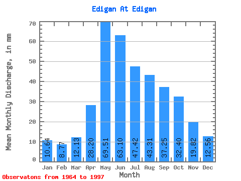
| Statistic | Jan | Feb | Mar | Apr | May | Jun | Jul | Aug | Sep | Oct | Nov | Dec | Annual |
|---|---|---|---|---|---|---|---|---|---|---|---|---|---|
| Mean | 10.63 | 8.85 | 12.13 | 28.20 | 69.50 | 63.10 | 47.42 | 43.31 | 37.26 | 32.39 | 19.83 | 12.57 | 383.95 |
| Standard Deviation | 5.98 | 8.12 | 18.34 | 38.51 | 50.56 | 50.56 | 48.67 | 46.23 | 36.96 | 27.01 | 10.82 | 3.79 | 329.29 |
| Min | 5.99 | 4.18 | 5.74 | 8.76 | 29.59 | 25.06 | 14.92 | 13.64 | 12.34 | 11.48 | 9.26 | 7.27 | 175.21 |
| Max | 40.94 | 50.89 | 110.31 | 233.28 | 326.46 | 302.40 | 295.86 | 276.73 | 228.34 | 160.68 | 71.59 | 23.97 | 2115.52 |
| Coefficient of Variation | 0.56 | 0.92 | 1.51 | 1.37 | 0.73 | 0.80 | 1.03 | 1.07 | 0.99 | 0.83 | 0.55 | 0.30 | 0.86 |
 Return to R-Arctic Net Home Page