|
|
|||||||||||||||||
| Point ID: 6693 | Downloads | Plots | Site Data | Code: 10084 |
|
|
|||||||||||||||||
| Download | |
|---|---|
| Site Descriptor Information | Site Time Series Data |
| Link to all available data | |
| View: | Time Series | All |
| Units: | m3/s |
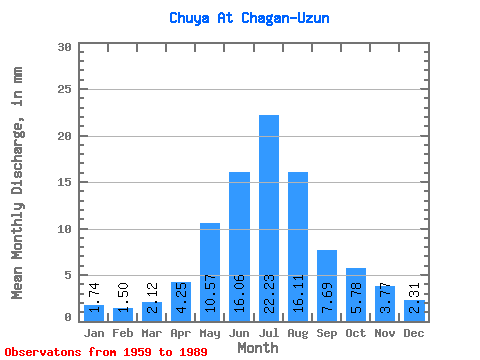
| Statistic | Jan | Feb | Mar | Apr | May | Jun | Jul | Aug | Sep | Oct | Nov | Dec | Annual |
|---|---|---|---|---|---|---|---|---|---|---|---|---|---|
| Mean | 1.73 | 1.51 | 2.12 | 4.25 | 10.56 | 16.06 | 22.23 | 16.11 | 7.69 | 5.78 | 3.77 | 2.31 | 93.42 |
| Standard Deviation | 0.49 | 0.71 | 1.46 | 1.60 | 2.48 | 3.86 | 6.28 | 4.13 | 2.14 | 2.01 | 1.48 | 0.88 | 21.93 |
| Min | 1.20 | 0.82 | 0.97 | 2.17 | 6.29 | 9.09 | 11.46 | 6.38 | 3.49 | 2.46 | 1.73 | 1.35 | 57.65 |
| Max | 2.48 | 3.16 | 5.57 | 7.54 | 13.78 | 24.37 | 40.60 | 24.72 | 11.69 | 10.18 | 6.56 | 4.22 | 135.76 |
| Coefficient of Variation | 0.28 | 0.47 | 0.69 | 0.38 | 0.23 | 0.24 | 0.28 | 0.26 | 0.28 | 0.35 | 0.39 | 0.38 | 0.23 |
 Return to R-Arctic Net Home Page