|
|
|||||||||||||||||
| Point ID: 6692 | Downloads | Plots | Site Data | Code: 10082 |
|
|
|||||||||||||||||
| Download | |
|---|---|
| Site Descriptor Information | Site Time Series Data |
| Link to all available data | |
| View: | Time Series | All |
| Units: | m3/s |
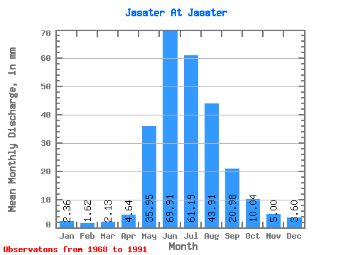
| Statistic | Jan | Feb | Mar | Apr | May | Jun | Jul | Aug | Sep | Oct | Nov | Dec | Annual |
|---|---|---|---|---|---|---|---|---|---|---|---|---|---|
| Mean | 2.36 | 1.63 | 2.13 | 4.64 | 35.94 | 69.91 | 61.19 | 43.91 | 20.98 | 10.04 | 5.00 | 3.60 | 271.00 |
| Standard Deviation | 1.03 | 0.82 | 1.17 | 3.61 | 10.03 | 15.95 | 18.95 | 20.44 | 10.83 | 2.54 | 1.43 | 0.98 | 38.73 |
| Min | 0.77 | 0.79 | 0.74 | 0.25 | 26.18 | 37.34 | 30.26 | 21.64 | 10.71 | 6.32 | 2.17 | 1.41 | 232.48 |
| Max | 3.81 | 3.23 | 3.78 | 11.67 | 61.12 | 96.94 | 91.69 | 88.66 | 48.18 | 15.28 | 6.44 | 4.55 | 319.57 |
| Coefficient of Variation | 0.43 | 0.50 | 0.55 | 0.78 | 0.28 | 0.23 | 0.31 | 0.47 | 0.52 | 0.25 | 0.29 | 0.27 | 0.14 |
 Return to R-Arctic Net Home Page